LINET view – Lightning Detection Visualisation

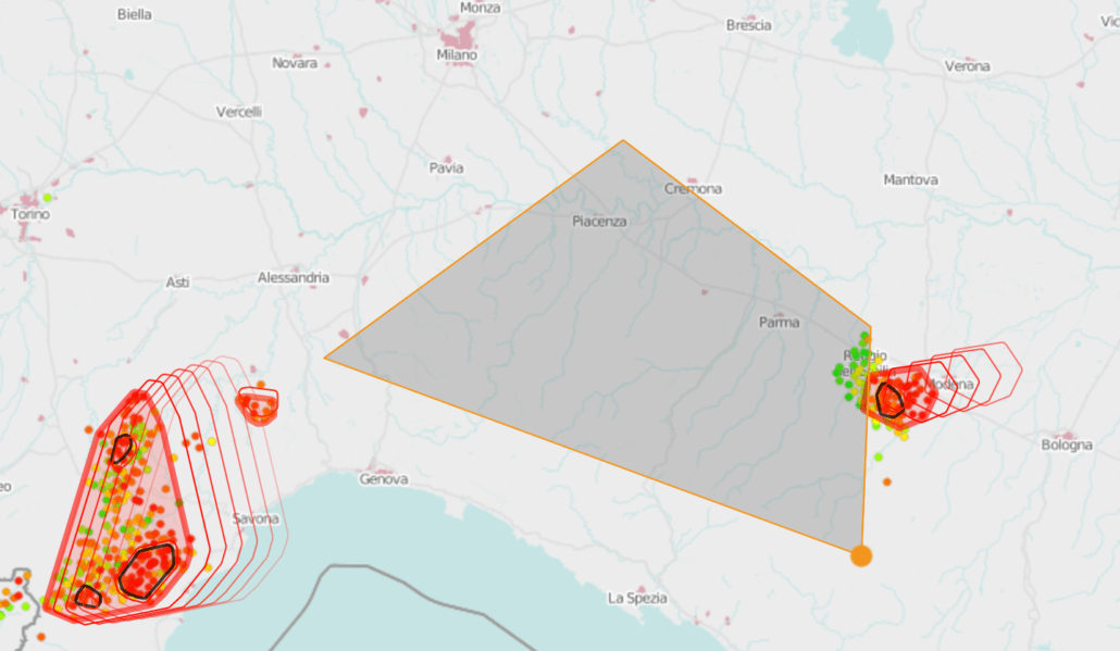
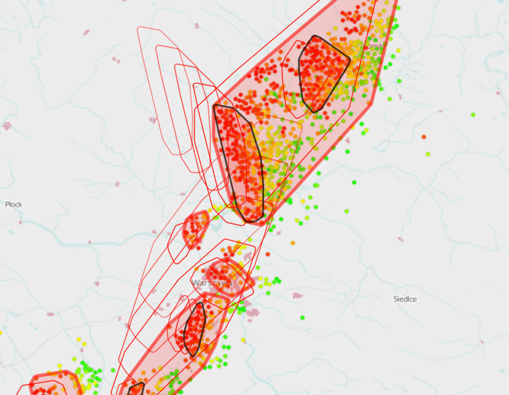
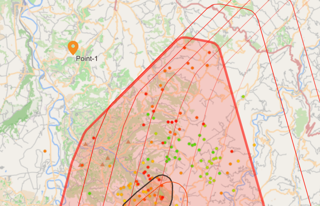
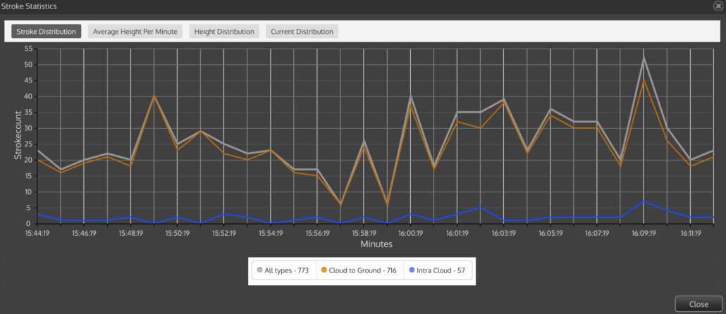
LINET view visualizes and analyzes the current or any historical thunderstorm situation in your web-browser on any device. Not only are strokes, thunder cells and nowcasting displayed on the map, but also any customer-specific elements (e.g. points of interest, transmission-grids, stations etc.) and individual alarm areas. The application is easy to use and provides many tools for the management of thunderstorm related risks.

With LINET view weather-dependent facilities such as e.g. airports, power lines, wind farms, pipelines, oil rigs and industrial facilities can be meticulously monitored resulting in detailed assessments of current or historical weather situations.

LINET view provides the user not only with a reliable estimated time of arrival (ETA) of the thunderstorm, but also ensures the protection of workers outdoors, the safety of events, the prompt location of the stroke site in the event of damage, as well as the immediate implementation of repair measures.

The most important advantages of LINET view

  • Web application on any device

  • Concise visualization of interactive map

  • Real-time and historical data

  • Displays lightning strokes, emission height, density, thunder cells, nowcasting, etc.

  • Statistics (flash distribution, amplitude distribution, height distribution)

  • Alarm areas with warning function

  • Displays any geographical structure (Shape-Files)

  • Layer with individual data (optional)

Who benefits from LINET view?

  • Weather services, energy suppliers, the army & industrial facilities

    If you do not have a geographical visualization system for real-time weather data in place, LINET view is the perfect solution for monitoring weather sensitive facilities. Weather services, energy suppliers, the army and industrial facilities use LINET view as a perfect control and reference system.

  • Airports

    Airports make use of LINET view in order to reduce the duration of turnaround stops to an absolute minimum. Aviation companies favor nowcast’s real-time tracking and nowcasting of thunderstorms algorithm (rTNT) for the perfect scheduling of their activities. Via individual alarm areas, users receive a warning as early as 60 minutes prior to the estimated time of arrival of a storm.

  • Oil rigs

  • Railway operators, wind farms, pipelines, power lines, event organizers

    Further user groups include railway companies (rail network), wind parks, operators of pipelines or power lines, the leisure industry, event organizers (open-air), operators of weather-sensitive facilities, and all other weather-dependent sectors. 

LINET view in detail

With LINET view nowcast has created a high-performance web application. LINET view geographically illustrates the current weather situation in an independent and flexible application, that meets a series of professional requirements.

  • Real-time and historical data

    In addition to the current weather situation in real-time, historical data since records began can also be displayed. Up to 48 hours at a stretch can be visualized on the map. Every single lightning stroke is plotted. The color of the individual strokes provides information about the timing, typology of the strokes as intra-cloud or cloud-to-ground stroke, or the height of any intra-cloud stroke. An on-screen stroke-density display is also available for selection.

  • Alarm region and warning

    To monitor weather sensitive facilities each user can individually define “points of interest” and alarm areas, either interactively using your mouse or by uploading shape files. These areas form the basis for alert-dispatch. If a thunderstorm approaches, the users in the affected alarm region(s) are informed automatically via on-screen warning, email, sms or other triggered warning devices like sirens or lights.

  • Data export

    In order to allow for the display of the data in other applications, for example in a 3D geo-browser, the export function stores all the available information pertaining to the area selected in a KML, TXT or ASC file.

  • Cell tracking and nowcasting

    LINET view is ahead of the curve. Since 2012 LINET view has been recognizing thunder cells. By means of special algorithms thunder cells are projected into the future at six 10-minute intervals (nowcasting). Users are warned of the thunderstorm in the alarm region one hour in advance.

  • Easy to use

    LINET view can be used on any device with internet connection and up-to-date web browser. It is easy-to-use, fast and intuitive. No special knowledge is required.

  • Individualization

    Are you interested in integrating LINET view into your company? We can customize LINET view web application with your logo and your corporate colors. As such, you can use the web application in compliance with your company’s CI. Upon request, additional layers such as radar can be integrated into LINET view.

  • Technical data

    All you need is an up-to-date web browser and an internet connection.

    • Mozilla Firefox: Version 3.6 or higher
    • Internet Explorer: Version 8 or higher
    • fast internet connection (recommended)
    • Mobile device browsers

Request a demo


    Your data will be used only to process your inquiry. Our Privacy Terms apply.

    form image